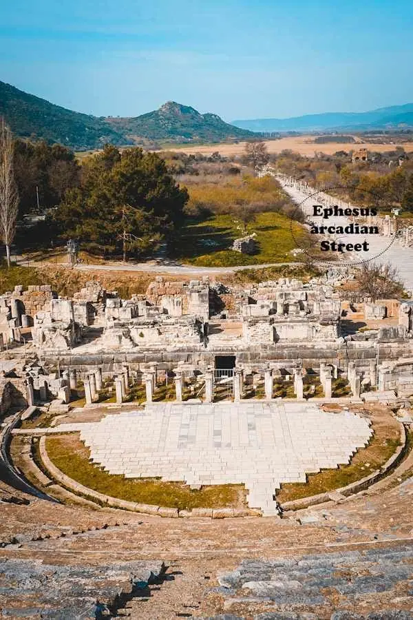
Aerial view along the Arcadian Way showing the layout of Ephesus
Plan your visit

The Biblical Ephesus Map

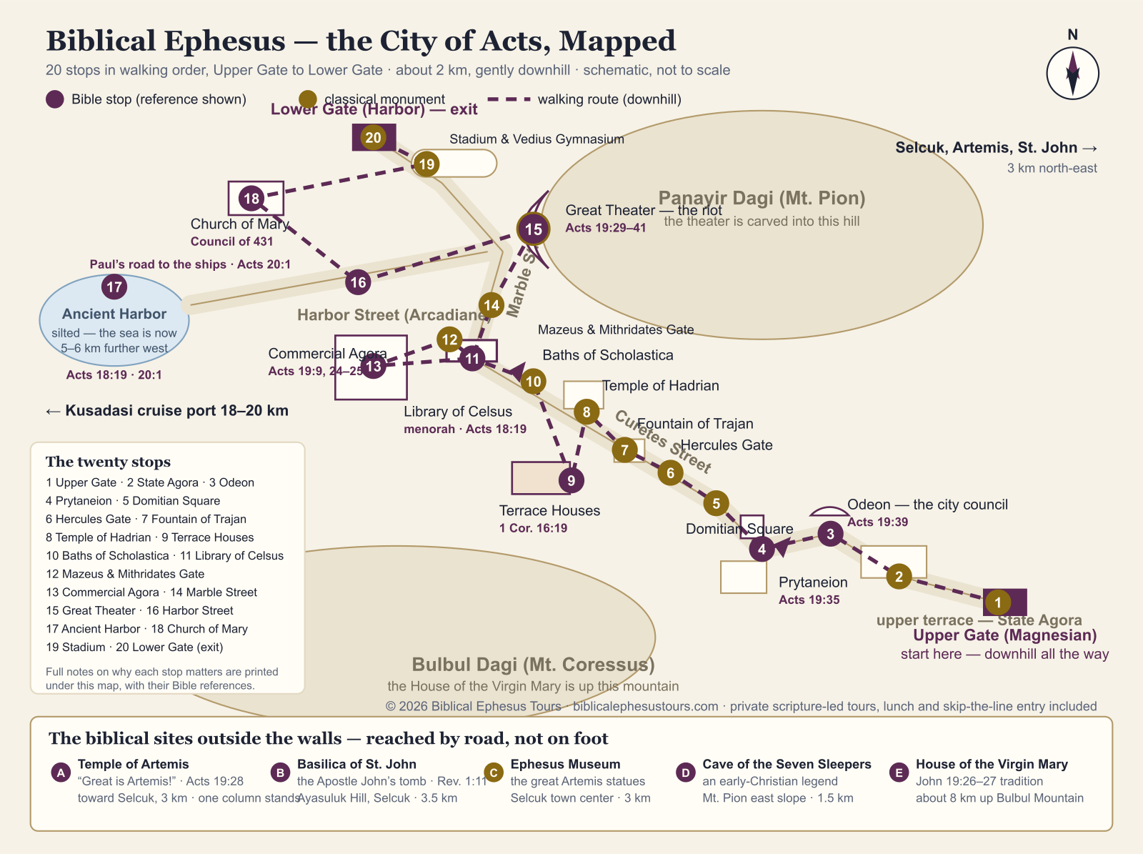
We drew the map we always wished we could hand our guests: a map of Ephesus in Bible times laid over the site you actually walk today — every place with a Scripture story marked in purple, verse and all. Print it, fold it, put it in your pocket.

Free to print and keep

The map

Biblical Ephesus map — a city plan of Ephesus with 20 numbered walking stops, Bible references for each biblical place, and the holy sites outside the walls
The city of Acts as a walking plan. Purple stops carry a Bible reference; gold stops are the classical monuments you pass between them. Schematic, not to scale.
Download the PDF map

Both are free. No email address, no sign-up — take the map and enjoy Ephesus.

Stop by stop

The twenty stops — and why they matter to a Bible reader

Numbers match the map, in walking order from the Upper Gate. Purple entries are the places where the Ephesus of the New Testament comes to the surface; the gold ones are the classical monuments you pass between them, worth a look for their own sake.

Upper Gate (Magnesian Gate)

Start here. This was the gate of the road from Magnesia, and entering from the top means the whole 2-kilometer walk runs gently downhill — the single best practical decision you will make all day.

State Agora & Basilica Stoa

The government square of Roman Ephesus — law, business and civic religion, the world the officials of Acts 19 belonged to.

Odeon (Bouleuterion)

Acts 19:39

The covered chamber where the city council sat. When the town clerk told the rioting crowd that grievances belong "in a lawful assembly," this machinery of government — council here, citizen assembly in the great theater — is exactly what he meant.

Prytaneion

Acts 19:35

The city's sacred hearth, where the flame of Hestia never went out. The clerk calls Ephesus the "temple keeper" of Artemis — an official title the city wore with pride, and this building embodied it. The two great Artemis statues in the Ephesus Museum were found right here.

Domitian Square

The terrace of the imperial cult temple — built a generation after Paul — useful for exactly that reason: it shows how fast emperor-worship grew in the very city where "gods made with hands" had just been challenged.

Hercules Gate

The narrow gate with Hercules carved on its pillars, marking where wheeled traffic had to stop. From here Curetes Street pours downhill in front of you — the classic Ephesus view.

Fountain of Trajan

One of the grand street fountains that made a Roman city livable. A colossal statue of the emperor once stood over the pool; a fragment of it survives in the museum.

Temple of Hadrian

The most photographed facade on Curetes Street after the library — its arch carries Tyche, and the inner door a figure many guides read as Medusa, warding the threshold.

Terrace Houses

1 Cor. 16:19

The frescoed homes of wealthy Ephesians, under a protective roof (separate ticket, and worth every lira). Rooms like these are where the first believers met: writing from Ephesus, Paul sends greetings from Aquila and Priscilla "and the church that meets at their house."

Baths of Scholastica

A bath complex renovated in the 4th century by a Christian woman named Scholastica — her headless statue still sits by the stairs. Even the plumbing here tells the story of the city's change of faith.

Library of Celsus

Acts 18:19

The postcard of Ephesus, built shortly after Paul's day. Look at the steps: a menorah is scratched into the marble — a quiet fingerprint of the Jewish community whose synagogue Paul entered when he first "reasoned with the Jews" here.

Gate of Mazeus & Mithridates

Two freed slaves built this triple arch in gratitude to their former masters — the emperor Augustus and his general Agrippa. It leads from the library square into the market — walk through it and you change worlds, from learning to commerce.

Commercial Agora

Acts 19:9, 24–25

The great market square, 110 meters on a side. This is the world of Demetrius the silversmith and his shrine-making trade, and the district where the hall of Tyrannus stood — the rented lecture room where Paul taught daily for two years.

Marble Street

The polished processional way between the agora and the theater, rutted by centuries of cart wheels. Watch your footing — two thousand years of sandals have left it slick.

Great Theater

Acts 19:29–41

The mountainside bowl that held some 25,000 people — and, for about two hours one afternoon, a crowd chanting "Great is Artemis of the Ephesians!" This is the stage of the riot of Acts 19, the most walkable chapter in the New Testament, and the emotional summit of the whole site.

Harbor Street (Arcadiane)

Acts 20:1

The grand colonnaded avenue from the theater to the docks. Every arrival and departure Luke records for Ephesus funneled along this line — after the riot, Paul said his goodbyes and walked this way to the sea.

Ancient Harbor

Acts 18:19 · 20:1

Now a reed-filled plain — the river pushed the coastline 5 to 6 kilometers west. But this silted basin is where Paul first stepped ashore in Ephesus and where he last sailed from it. The empty field says more about the city's fate than any ruin.

Church of Mary (Double Church)

Council of 431

A long hall church near the harbor, very possibly the first church in the world dedicated to the Virgin Mary. The Council of Ephesus met here in AD 431 and proclaimed her Theotokos — "God-bearer" — a decision every mainstream Christian confession still holds.

Stadium & Vedius Gymnasium

The sports quarter of the Roman city, near the exit. Later tradition remembered Christians facing the arena here, which is why parts of it were pulled down with feeling once the empire changed faith.

Lower Gate (Harbor Gate)

The exit — and the smart place to have your driver waiting, so nobody walks the 2 km back uphill. Our tours position the vehicle here while guests are still up at the theater.

Outside the walls — the holy sites you drive to

Temple of Artemis

Acts 19:27–28

One of the Seven Wonders of the Ancient World, the temple whose silversmiths started the riot. One reassembled column stands in a marshy field — often with a stork's nest on top. Three kilometers toward Selcuk, free to visit.

Basilica of St. John

Rev. 1:11

Emperor Justinian's great church over the tomb venerated as the Apostle John's since antiquity — the man tradition names as writer of the Gospel, the letters, and the Revelation whose first letter came to Ephesus. On Ayasuluk Hill in Selcuk, 3.5 km away.

Ephesus Archaeological Museum

Where the site's treasures live, including the two astonishing Artemis statues found in the Prytaneion. Seeing her many-layered figure explains the riot better than any lecture. Selcuk town center.

Cave of the Seven Sleepers

early tradition

The beloved legend of seven young Ephesians who fled persecution, slept in a cave, and woke to find the empire Christian. The cave church complex on the east slope of Mt. Pion is viewed from the outside — and the story is told in both Christian and Islamic tradition.

House of the Virgin Mary

John 19:26–27

The small stone house on Bulbul Mountain venerated as Mary's final home, in the care of the Apostle John — a tradition rather than a certainty — and one that three popes have come to pray over. About 8 km up the mountain road; shoulders and knees covered.

Most first-time visitors picture Ephesus as a sprawling field of ruins and worry about getting lost. It is actually one of the easiest ancient cities in the world to navigate: a single marble street runs downhill through a narrow valley between two hills, with a gate at the top and a gate at the bottom. Everything famous sits on or just off that one street — which is why a map of Ephesus in Bible times fits so neatly onto one printable page.

Take the map with you — free PDF, no strings

The map above is ours, drawn for this page, and you are welcome to keep it. The PDF version is laid out for a single A4 sheet in landscape, so it prints cleanly on any hotel or ship printer, and the print button turns this whole page into a handout — map on the first sheet, the numbered stops with their verses after it. We ask for nothing in return, not even an email address. Fold it, mark it up, read the verses on the spot; that is what it is for.

One honest tip from people who walk this site every week: paper beats a phone at Ephesus. There is almost no shade, screens fight the glare, and batteries suffer in the summer heat. A folded page in a back pocket never runs out of charge.

The two gates — and why the upper one matters

The Upper Gate (also called the Magnesian Gate) sits at the higher, southern end. The Lower Gate is at the northern end near the Great Theater. Between them is about two kilometers of walking. Enter at the top and the entire route is gently downhill on ancient marble; enter at the bottom and you climb it. Tour drivers know this; independent visitors sometimes learn it the hard way, uphill, at noon. If you can choose, choose the top.

What the official site map will not tell you

The boards at the gates show the excavated zone only — roughly a tenth of the ancient city. The blank areas on the plan are not empty ground; they are unexcavated Ephesus, including, in all likelihood, the synagogue where Paul first reasoned and the lecture hall of Tyrannus. That is why our map marks the commercial agora district for the hall rather than pretending to a precision nobody has: when your guide says the city held perhaps two hundred thousand people, the plan in your hand is showing you the tip of it.

You may also spot, high on the slope above Curetes Street, the fenced path to the cave church known as the Grotto of St. Paul, with its early frescoes. We mark it nowhere on the walking map for a simple reason: it is closed to visitors, no reopening date has been announced, and tours do not go there. Better to know that before you climb a hill in July.

A note on gradients and surfaces

The marble is genuinely slippery where millions of feet have polished it, especially on the steep Curetes stretch, and there is very little shade between the Hercules Gate and the library. Downhill from the top gate is the kind, sensible direction, and it is the way we walk it with every guest.

Sources & further reading

Good to know

Frequently Asked Questions

Is there a printable map of biblical Ephesus?

Yes — the map on this page. Download it as a free A4 PDF or use the print button, which prints the map together with the numbered stop list and Bible references. We do not ask for an email address or a sign-up — just take it.

What does the map of Ephesus in Bible times show?

Twenty numbered stops in walking order from the Upper Gate to the Lower Gate, with every biblical place marked in purple and its verse shown — the theater of the Acts 19 riot, the agora of the silversmiths, the harbor Paul sailed from — plus the five sites outside the walls — four holy places and the Ephesus Museum — with road distances.

Which gate should I enter Ephesus from?

Enter at the Upper Gate (Magnesian Gate) if you can. The route is then downhill the whole way to the Lower Gate near the Great Theater. Entering from the bottom means walking uphill on marble, often in full sun.

How big is the Ephesus site and how far do you walk?

The excavated site runs about 2 km from the Upper Gate to the Lower Gate. Walking it in one direction with normal stops takes roughly 2 to 3 hours.

Are the House of the Virgin Mary and St. John's Basilica inside Ephesus?

No — that surprise derails a lot of self-planned days. Mary's house is about 8 km up Bulbul Mountain and the Basilica of St. John is 3.5 km away on Ayasuluk Hill in Selcuk. Both appear on our map's "outside the walls" strip with distances; both need transport and separate tickets.

Why is the Grotto of St. Paul not on the map?

Because it is closed to visitors and no reopening date has been announced, so putting it on a walking map would only send you up a hot hillside for nothing. Tours do not visit it. The famous Paul and Thecla frescoes inside are published in archaeological literature if you want to see them.

Is the map to scale?

No — it is a schematic plan, like a metro map: the order of stops, the street connections and the walking route are right, but distances and building sizes are simplified so everything stays readable on one page. Real distances are written on the map wherever they matter.

Can I use my phone instead of a paper map?

You can — the page works well on a phone and the site has decent signal. But there is almost no shade at Ephesus, glare makes screens hard to read, and summer heat eats batteries. Our advice is still the folded paper in a pocket, with the phone saved for photographs.

Rather have the map walk itself?

Every stop on this page is part of our private tours — with a guide who reads the verses on the very spot.

TÜRSAB license No. 15746No prepayment to inquireFree cancellationSkip-the-line entrance included